(View my alternative proposal for filling the critical gaps in the Menlo Park Bike network through investments in bike lanes on streets other than El Camino Real.)
Today El Camino Real (ECR) is a heavily travelled vehicle artery that primarily serves the transportation needs of motorists who are residents, visitors or simply passing through Menlo Park. The planned large multi-use developments at 500 and 1300 ECR, the huge 800,000 square foot expansion of the medical facilities underway at Stanford and new commercial developments in Redwood City and Palo Alto are all rapidly expanding the demand for vehicle capacity and this will become especially evident at peak commute times. While growth has been accelerated during the current economic recovery the long term motorist demand will remain robust for at least another 10 years, and Menlo Park’s ability to meet this demand with adequate vehicle capacity will remain severely limited. So what actions can Menlo Park take to prevent transportation problems from severely reducing the City’s overall quality of life? Are there actions that might actually improve it? Currently Menlo Park is studying alternative configurations for ECR. Would these enhance or reduce the long term quality of life in Menlo Park? While ECR Real could be enhanced in many ways to improve resident quality of life, my current focus is on transportation needs.
Menlo Park’s one-mile+ segment of ECR should be in the context of four separate local transportation networks, one for motorists who use either four wheel vehicles or motorcycles/motorbikes, another for cyclists, a third for pedestrians, and a fourth for public transit. These local networks connect to similar networks at the boundaries of Menlo Park. Networks are by their nature systems and long term solutions to addressing particular needs and problems should only be viewed from a systems perspective.
Any change in the future usage of a supply-constrained highway like ECR will require the careful consideration of important trade-offs, and in order to make the best decision, Menlo Park needs to…
- Have a pragmatic long term vision for how this scarce and important resource could enhance quality of life of its residents.
- Carefully weigh the long term interests of users who prefer different modes of transportation in their daily lives.
- Ensure that the city is providing transportation options that are as safe as reasonably possible.
My Current Impressions
The transportation capacity of ECR can be significantly expanded only thru regional public and private transit solutions that substitute buses for personal vehicles. Relying on either expanded Caltrain services or new track-based services like a BART extension is unrealistic.
- Hi-tech companies have already demonstrated the huge value of transporting employees with convenient private bus networks.
- Peninsula counties are exploring how to expand regional public bus networks using ECR as a central artery.
- Stanford should be encouraged/pressured/incented to provide a regional private bus network service for its employees. This could use ECR, Highway 280, and Highway 101.
.
The good news is the American love affair with personal car ownership is waning as the under 30 age group turn to alternatives. The popularity of ride-hailing services like Lyft and Uber has growing rapidly; the costs of electric bikes/motorbikes are declining; and motorcycles and scooters will likely become more common as in European cities. The implications are huge. Perhaps in the next 5 to 10 years one ECR vehicle lane in each direction could be dedicated to buses and two wheel vehicles including bicycles. This would be greatly improve the quality of life in Menlo Park and have big environmental benefits.
.
I do NOT believe adding bike facilities to ECR would attract a significant number of cyclists nor be as safe as potential alternatives. I do believe bike facilities would negatively impact motorists and pedestrians and preclude more valuable uses for ECR. Plus, bike riding access to downtown and ECR destinations and east-west connectivity could all be made more comfortable, convenient and safe by making bike improvements to nearby streets. All of the following changes are included in the Menlo Park Specific Plan.
- Add bike lanes to University Avenue between Middle Avenue and Menlo Avenue. Remove street parking.
- Add bike lanes to Menlo Avenue between University and ECR. Remove street parking
- Add bike lanes to University Avenue between Santa Cruz Avenue and Valparaiso Avenue.
- Extend bike lanes on Ravenswood Avenue to ECR.
- Add bike lanes on Oak Grove between University and ECR.
Note: Additional small improvements might be necessary to tie network links together.
What is the ECR Corridor Study?
The Menlo Park City Council initiated this study to determine how El Camino Real might be re-configured in ways that better serve the needs of its residents including motorists, bike riders, businesses, property owners and pedestrians. Here is the consultant’s proposal.
Who is performing the study?
There are many contributors.
- The City Council provides top-down direction through the Menlo Park Transportation Division and makes the final decisions on what actions will be taken after the study is completed.
- The Transportation Division is leading the research and analysis of alternative solutions.
- A traffic consultant (W-Tran) is assisting with designs and usage forecasts.
- The volunteer Menlo Park Bike Commission consists of Menlo Park cyclists who provide advice.
- Other volunteer commissions, e.g., transportation, planning, review study results and make recommendations.
What is the current status of the study?
In June 2015 the City Council will review the conceptual analysis of each alternative and the recommendations of the bike, transportation, and planning commissions. It will then decide which projects will be studied in greater detail. This additional work will include environmental impact reports, detailed plans and cost estimates.
What key decisions are being considered?
- Whether to add either bike lanes or physically separate bike paths along El Camino Real from the City’s southern boundary to Encinal Avenue.
- Whether to have three vehicle lanes in each direction on El Camino Real. Today there are only two lanes north of Ravenswood.
- Whether to make improvements to the Ravenswood Avenue intersection that could reduce vehicle traffic congestion at commute times.
What are the current city recommendations?
- The City Council has not expressed its preferences.
- All commissions appear to currently support the improvement of the Ravenswood Avenue intersection and the addition of bike lanes.
July 2015 Consultant Report
Balancing Resident Interests
.

Each of the changes being considered for El Camino Real will significantly impact the convenience, comfort and safety of ALL Menlo Park residents so optimal decisions should only be made after all significant trade-offs are identified, sized and evaluated and weighed in a fair and balanced manner. The above “potential impact table” identifies the primary groups who would be impacted. The comparison is with the alternative of bike riders using available routes other than El Camino Real.
Menlo Park Bike Network
Menlo Park continues to improve its comprehensive Bike Network with additional bike lanes and signage. Today there are bike lanes on Laurel, Alma, Santa Cruz Avenue between University Avenue and Orange Avenue, Valparaiso, Ravenswood and Middlefield. Middle is a bike route. Menlo Avenue and the section of University between Middle Avenue and Menlo Avenue are designated as shared bike-vehicle streets. When the Greenheart project is built there will be a continuous bike lane created between Encinal Avenue and San Francisquito Creek using Alma, Garwood and a connector across the Greenheart property.
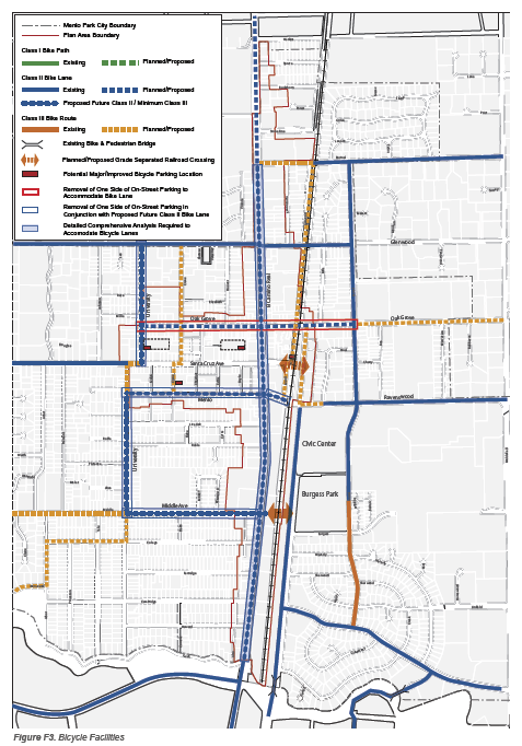
Bike Network Improvements Proposed in The Menlo Park Specific Plan
Here is a list of the improvements recommended in the Specific Plan. The City has neither set implementation priorities nor timeframes.

Popular Bike Routes
Menlo Park offers bike riders safe and convenient ways to travel to and from destinations downtown and on El Camino Real through a comprehensive network of well marked bike lanes and bike routes plus quiet residential streets.
Popular North-South routes on the east side of El Camino Real:
- Bike lanes on Alma Street from the Menlo Park-Palo Alto bike bridge to Ravenswood Avenue.
- Bike lanes on Laurel Street from Willow Road to Encinal Avenue
- Bike Lanes on Middlefield Road from Palo Alto to Redwood City
- (Planned) Bike Lanes on Alma Street to Oak Grove + Bike Connector across the GreenHeart property + Way to Encinal Avenue
North-South routes on the west side of El Camino Real
- Bike Routes and shareways on University Avenue from Creek Drive to Valpariso Avenue
- Fremont Street between Middle Avenue and Santa Cruz Avenue
- Bike route on San Mateo Drive and Wallea Drive from Menlo Park-Stanford bike bridge to Valparaiso Avenue
East-West routes on the east side between Middlefield Road and El Camino Real
- Bike lanes on Willow Road, Ravenswood Avenue and Encinal Avenue
- Bike routes on Oak Grove and Glenwood Avenue
- Bike route on Middle Avenue from Olive to University
East-West routes on the west side between El Camino Real and Olive Street/Hillview Drive
- Bike route on Middle Street to University Drive
- Bike Lane on Santa Cruz Avenue from Orange Avenue to University Drive
- Valparaiso Avenue
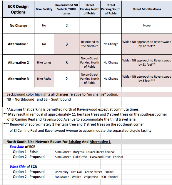
Four Design Alternatives
While the study has focused on three new designs for re-configuring El Camino Real the City could decide to leave it “as is”; this is the no change alternative.
- Existing (No Change)
- Alternative 1: Three vehicle lanes in each direction for the entire length of El Camino
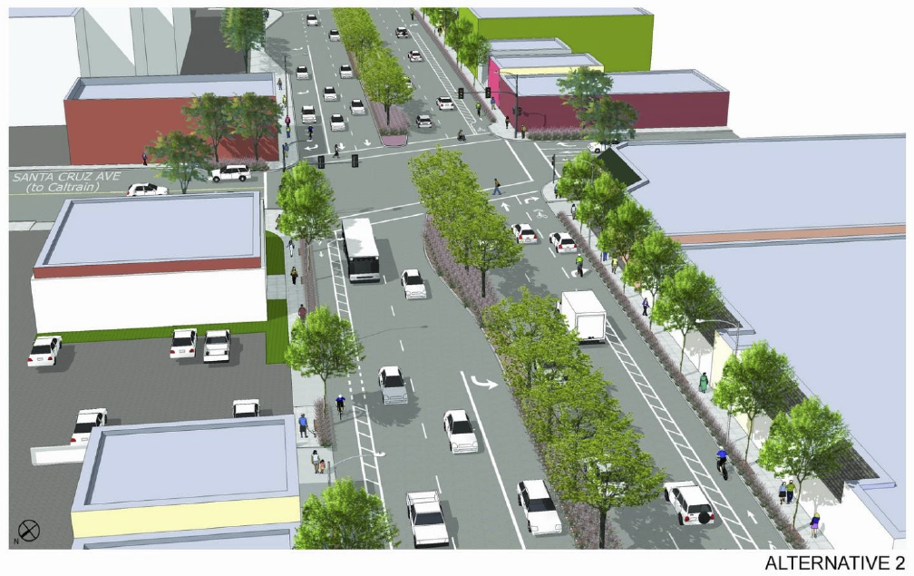
- Alternative 2: Add Buffered Bike Lanes, three thru vehicle lanes at Ravenswood Avenue, two northbound vehicle lanes north of Santa Cruz Avenue
- Alternative 3: Add Separate Bike Paths, two thru vehicle lanes at Ravenswood Avenue, two northbound vehicle lanes north of Ravenswood Avenue
What potential trade-offs are associated with making improvements to the Ravenswood Avenue intersection?
Potential Benefits:
- Reduces the congestion-related delays experienced by motorists traveling on El Camino Real, especially at commute times.
Potential Drawbacks:
- Requires the removal of an unknown number of large redwood trees at the southeast corner of the intersection.
What potential trade-offs are associated with having three vehicle lanes in each direction on El Camino Real?
Potential Benefits:
- Reduces overall vehicle congestion on El Camino Real.
- Reduces the number of vehicles through nearby neighborhoods.
Potential Drawbacks:
- Third vehicle lanes in both directions north of Ravenswood Avenue attracts so many new motorists that no congestion relief occurs. (This is the consultants’ view based on computer modeling.)
What potential trade-offs are associated with adding either bike lanes or physically separate bike paths along El Camino Real from the City’s southern boundary to Encinal Avenue?
Potential Benefits:
- More bike riders enjoy the convenience of traveling on El Camino Real.
Potential Drawbacks:
- Bike lanes and paths create the illusion of safety for bike riders, and as more bike riders used El Camino bike riders, motorists, and pedestrians are regularly exposed to dangerous situations that result in collisions, accidents and “road rage”. There are about sixty places at driveways and intersections where bike riders could either merge or cross paths with motorists and pedestrians, and they CANNOT be protected by either bike lanes or physical barriers.
Who stands to gain and lose the most from either bike lanes or bike paths?
It is uncertain how many cyclists would benefit. Cyclists can be categorized as the “Strong & Fearless” (< 1.5% of the entire typical biking community), the Enthused and Confident” (<10.5%), and the Interested But Concerned” (< 90%). All might be attracted by separate bike paths but only the first two types would likely be attracted to bike lanes. Both would impact property owners, businesses, motorists and pedestrians. Studies have shown that the “Strong and Fearless” types actually prefer no bike facilities as they find these limit their freedom. Current riders on ECR are likely to be either the “Strong and Fearless” or cyclists who are simply unaware of or unwilling to take alternative routes.
The Minteta Transportation Institute (MTI) recommends a methodology for gauging the appeal of a bike network that considers the tolerance individual riders have for traffic stress, the level of stress produced by the link itself, and the amount of detour associated with using a lower stress alternative link. This methodology is described in MTI’s “Low Stress Bicycling And Network Connectivity” study. The ECR Corridor Study consultant has proposed performing this type of analysis and Re-Imagine Menlo Park has already completed one. I have concluded that few cyclists would use either bike lanes or bike paths on El Camino, and these would not be suitable for the largest group of cyclists, elementary and school age children. This analysis can be downloaded at XXX.
Gainers
- Cyclists who have the experience, skills, and awareness to minimize dangerous encounters with motor vehicles that cross their paths at both street intersections and at mid-block public driveways AND who prize the possibility of shaving several minutes off travel times.
Losers
- Bike riders – think school children and adults who are comfortable riding on residential streets – but are ill-equipped to handle the demands and dangers of riding on El Camino. Ironically, the existence of either bike lanes or paths would encourage more to do so by creating the illusion of safety.
- Motorists would frequently be exposed to a large number of potential bike collisions and accidents as they interact with more slowly moving bike riders. Motorists would also experience delays whenever they must wait for bikes either directly or are caught behind a turning vehicle.
- Pedestrians would be endangered by mixing with bike riders at busy intersections regardless of how crosswalks are marked. Inevitably, there would be confusion, angry exchanges and accidents.
- Everyone might be negatively impacted by longer response times for fire trucks, police cars and ambulances as emergency vehicles would need to avoid collisions and accidents with cyclists and bike riders.
The Safety Illusion
The frequency of accidents between vehicles and bikes on a particular stretch of highway like El Camino Real is determined by many factors: the actions of individual motorists and bike riders, the amount of bike and vehicle traffic, the number of places where vehicle cross paths with bike riders at intersections and public driveways, the number of parking spaces where a motorist could either open a car door or pull out in front of a bike rider, and the existence of safety measures. It seems intuitively obvious that bike lanes and paths would make any road much safer but unfortunately that is not the case. For example, the bike lane alternative described in the El Camino Corridor Study would eliminate some street parking but increase daily bike usage north of Ravenswood Avenue from 132 to 475 riders. Since most of the additional riders would likely not be experienced cyclists, it is reasonable to expect that accident rates would increase. So if the bike lanes improved safety by 25% but the less experienced riders had twice the rate of accidents we end up with a higher over all accident rate. Experienced cyclists: Accident rate = X% Number of riders: 132 Inexperienced bike riders: Accident Rate = 2X%* Additional riders: 343 Net Accident rate: 132 (X%)/475 + 343 (2X%)/475 = 1.72X So the accident rate for the mix of bike riders would increase by 72%. * This accident rate is used simply to illustrate how more less experienced bike riders impact an overall accident rate.
Dangerous Situations
Most vehicle-related, bike accidents and injuries occur where motorists cross the paths of bike riders, and the two most common locations are intersections and mid-block public driveways, e.g., Safeway, Shell Service Station, McDonald’s, and Bev Mo. Here safety measures like bike lanes provide little protection because riders must leave bike lanes and share vehicle lanes with motorists until riders have passes these spots. These dangerous interactions also can can create significant inconvenience. The following example illustrates insights wide variety of situations that will inevitably occur due to chance, distractions, poor judgment and unanticipated actions by a motorists, bike riders or both. While safety would be improved IF everyone faithfully followed the rules, assuming this is unrealistic. While pure accidents involving no errors in judgment can occur anywhere, some situation are simply inherently more dangerous than others.
Example – Bike Lanes – Interactions At Santa Cruz Intersection
A motorist is driving southbound on El Camino and approaching the intersection at Santa Cruz Avenue where there exists a shared right turn lane. A little behind the driver two bike riders are travelling in the same direction in a bike lane at a much slower speed and separated by about fifty feet.
Situation 1: The traffic signal is green and both the motorist and bike riders intend to travel thru the intersection. Safe outcome. No inconvenience.
Situation 2: The traffic signal is green and the motorist intends to make a right turn. The motorist patiently yields to both bike riders, merges into the shared vehicle lane and turns only after the bike riders have safely cleared. Safe outcome. Following motorists are delayed.
Situation 3: The traffic signal is green and the motorist intends to make a right turn. The motorist either has not seen the bike riders or misjudges the situation and unsafely enters the shared vehicle lane either in front of them or into them. Bad outcome.
Situation 4: Similar to Situation 3 but the motorist makes a “last minute” decision to make a right turn, is travelling at a higher speed and turns unsafely in front of the bike riders. Bad outcome.
Situation 5: Either the traffic light is yellow or the motorist thinks its about to change to yellow. The motorist tries to beat the signal, enters the turn lane unsafely as in Situation 4. Bad Outcome.
Situation 6: The traffic signal is red and the situations are similar to Situations 1, 2 and 3. Safe outcome if the interaction is like Situations 1 & 2. Bad outcome if interaction is similar to Situation 3.
Five Major Intersections, Eight Regular Intersections and Sixty Public Driveways
El Camino Real has an unusually high density of spots where bikes and vehicles can cross paths on a regular basis: more than seventy in a little over a mile between Encinal Avenue and Creek Drive. Bike lanes provide no protection for either the bicyclist or motorists at these spots.
- Vehicles and bikes share a right hand turn lane at each major intersection.
- There are no merge lanes at standard intersections nor at public driveways where vehicles simply cross bike lanes to either enter or exit El Camino Real.
- To make a left hand turn on El Camino bicyclists must either cross multiple vehicle lanes and merge with vehicles in the left turn lane or go through an intersection, stop and wait for the east-west traffic signal to turn green and then cross El Camino Real. In the latter case, if the bicyclist encounters a red light when approaching the intersection a left hand turn would require two light changes.
Mid-Block Public Driveways

What are the primary shortcomings of this study?
- The actual NEED for bike lanes on El Camino Real has not been demonstrated. No analysis has been performed to compare the RELATIVE convenience of riding bikes on either El Camino Real or using nearby streets including ones in the official Menlo Park Bike Network.
- Bike lanes and paths and the removal of some on-street parking would create some incremental safety for bike riders and cyclists riding on El Camino Real However, the RELATIVE safety of bike riding on El Camino Real with these safety measures versus on other nearby streets including ones in the official Menlo Park Bike Network has NOT been evaluated.
- The safety and convenience of motorists at intersections and public driveways could be significantly compromised by bike riders in bike lanes and paths but this issue has not been evaluated.
- Both Menlo Park and Palo Alto have relied on a bike network design expertise of Alta Design + Planning when they developed their bike network plans and priorities. Menlo Park has not sought their advice during this study.
- Vehicle traffic projections performed by the consultant indicate adding a third lane north of Ravenswood Avenue would not reduce congestion and neighborhood “cut-thru” traffic – counter-intuitive findings – but this claim is poorly explained, e.g., what is the confidence level for this projection? Instead, the study team presumes single value, “expected numbers” are sufficient and should simply be accepted.
How can residents ensure their preferences determine what decisions are ultimately made?
Sending an email is most effective way to communicate your preferences and concerns to City Council members in writing. Residents should also attend the City Council meeting makes it makes its decisions and if comfortable doing it, present their views.
My Current Position
I strongly prefer NOT to encourage more bike usage of El Camino Real as I believe the benefit of making this highway marginally more convenient and safe for experienced cyclists is greatly outweighed by the dangers and inconvenience that would be experienced by bike riders, pedestrians and motorists. And, a better use of precious space on El Camino would serve multiple modes of transportation excluding automobiles. Therefore, I oppose both bike lanes and separate bike paths. This chart illustrates my intuitive beliefs about how different users would be impacted. The comparison is with the alternative of bike riders using available routes other than El Camino Real.
I have also proposed that the city shift the already budgeted but unspent funds for the planned Corridor Study to other bike network improvements which address more critical needs: east-west connectivity and downtown access.
View proposal.

My Other Publications
My Email to The City Council. Planning, Transportation and Bike Commissions (April20, 2015)
Guest Viewpoint in The Almanac (April 15, 2015)
My Letter to The Planning Commission And City Council (April 2, 2015)
The Menlo Park “Complete Street” Policy Does NOT Require Bike Facilities on El Camino. (Published March 25, 2015)
El Camino Real Corridor Study: Let’s Try Three Lanes Each Way And See How Well It Works. (Published March 16, 2015)
The El Camino Real Corridor Study: Why Adding Bike Facilities On ECR Would Needlessly Jeopardize Cyclist, Driver And Pedestrian Safety. (Summary)(Published March 15, 2015)
The El Camino Real Corridor Study: Your Voice Needs To Be Heard. (Published February 22/Updated March 9, 2015)
The El Camino Real Corridor Study: How To Make Menlo Park More Bike Friendly (Analysis & Recommendations)(Published February 21, 2015)
A Close Look At The Study And Alternatives
City Planning Documents
This link takes you to all the ECR Corridor Study planning documents and presentations published by the Menlo Park Transportation Division.
Study Calendar
- Complete the Study (TBD – 2016?)
- Complete The Concept Analysis Phase of the Study (June 2015)
- Planning Commission Review (April 6, 2015)
- Transportation Division Report To Bike, Transportation and Planning Commissions (March 15, 2015)
- Second Online Resident Survey (February 19, 2015 thru March 13, 2015)
- Public Work Shop 3 – Present Alternatives, Preliminary Analysis, Participants Rank Alternatives (February 19, 2015)
- Transportation Division Report To Bike And Transportation Commissions (November 12, 2014)
- Public Workshop 2 – Summarize feedback from first online survey, identify best practices, discuss design options (October 1, 2014)
- First Online Resident Survey Public Workshop 1 – Identify Issues, suggest ideas for improving El Camino (April 30, 2014)
Current Vehicle Traffic

Current Bike Usage
- Table source: ECR Corridor Study
- 65% of cyclists are using the Palo Alto Avenue/Sand Hill Road/ECR = 256 cyclists
- 35% of cyclists are using FOUR Menlo Park ECR intersections = 136 cyclists.
- Are most riders simply crossing El Camino Real to reach their destinations?

Future Bike Usage – 20 Year Projections

Qwik Reference Comparison Of Four Designs
Understanding Lane Charts
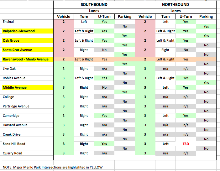
When looking at the following charts imagine you have an aerial view of El Camino and you are traveling in the direction of the arrows. The horizontal lines just below a street names represent intersections. Here are a few examples: Chart – Existing Traveling northbound on ECR and approaching Roble Avenue.
- Three thru vehicle lanes
- A left-turn vehicle lane
Traveling northbound ECR and approaching Valparaiso/Glennwood Avenues
- Two thru vehicle lanes
- A left-turn vehicle lane
- A right-turn vehicle lane
Traveling southbound on ECR and approaching Ravenswood/Menlo Avenues
- Two thru vehicle lanes
- A left-turn vehicle lane
Existing Design – A Closer Look


Three Vehicle Lanes – A Closer Look


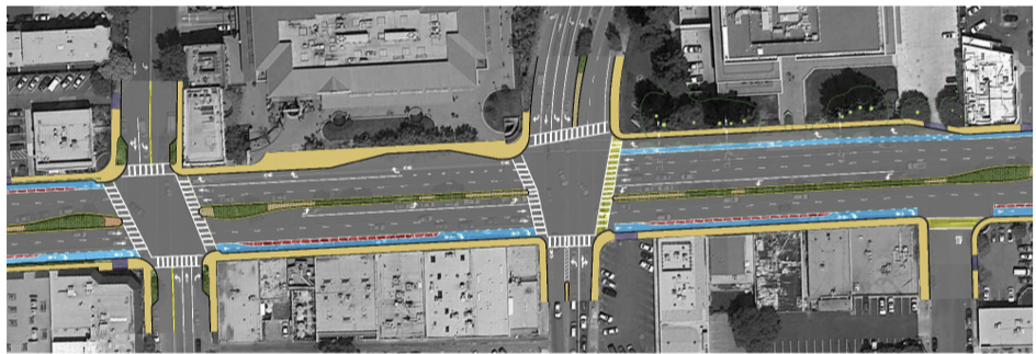
Buffered Bike Lanes – A Closer Look


Separate Bike Paths – A Closer Look


Menlo Park Resources
The El Camino Real Corridor Study website
November 14, 2014 Study Report
Additional Bike Network Resources
2012 National Bike Safety Report
City Of Palo Alto Bike + Pedestrian Transportation Plan Palo Alto Bike Network
My Intuition
I believe no one will benefit from encouraging more bicylists on El Camino Real other than some experienced cyclists who might fiind El Camino Real a marginally more convenient route between a few origins and destinations. The following table provides a summary of my intuitive beliefs about the winner and losers. I had hope the study would have effectively provided this analysis and do not understand how sound decisions can be made without it.
