[vc_row][vc_column][vc_column_text]

 [/vc_column_text][vc_message icon_fontawesome=”fa fa-bicycle”]Why Doesn’t The Bike Project Field Trial Evaluate Bike Safety Claims – April 12, 2017
A few weeks ago, a collision between my road bike and a white pick-up truck on Woodside Road reminded me that even well marked bike lanes afford little safety and no protection. Seeing a narrow gap in the flow of vehicle traffic, the driver shot across the two-lane highway from a service station driveway on his way to the Pioneer Inn and did not spot me riding in a well-marked bike lane until it was too late. He braked hard but ended up straddling my lane less than 10 feet in front of my front wheel and our collision was unavoidable. If the truck had arrived a few seconds later, I might have ended up underneath. My bike was badly damaged, but fortunately, I was not seriously injured. Since this incident occurred as the Menlo Park prepares a plan for a one-year, field trial of the Oak Grove – Crane – University (“Oak Grove”) bike project, my accident caused me to reexamine the primary rationale for this city investment and the trial metrics that city staff has proposed to gauge potential benefits and negative impacts. So far, the City Council has accepted the bike commission’s claim that this bike project will greatly improve bike safety – especially for students who must cross El Camino to reach their schools. But how does anyone really know? This important claim remains unexamined, and the current field trial plan does not adequately address bike and motorist safety issues. Instead, the Council, bike commission and many residents have incorrectly accepted as an “article of faith” the belief that new bike lanes always create a much safer bike riding environment. While the Council in a March review instructed city staff to better understand the impact of lost street parking, it should also require that more attention be paid to understanding the safety attributes of the project design and NOT approve a final field trial plan before safety receives greater attention both before and during the field trial.
Read Entire Letter (including maps of potential trouble spots)[/vc_message][vc_message message_box_style=”outline” icon_fontawesome=”fa fa-bicycle”]Letter To City Council: Proposed Metrics For Bike Project Are Woefully Inadequate – March 27, 2017
It is not easy to make decisions that require trade-offs between competing interests, what the Menlo Park City Council now faces, as it considers a field trial to evaluate the Oak Grove-Crane-University Bike Project (“OCUBP”). Such decisions are particularly challenging when a minority of residents might benefit at the expense of a larger group, in this case bicyclists at the expense of motorists who drive and park on affected streets, residents who live there, and schools and businesses that operate either on or near the effected streets. That said, residents always expect their city leaders to demonstrate care, wisdom and fiscal responsibility and to acquire the information needed to make the best possible decisions, generate maximum community support, minimize misunderstandings and avoid potential backlash.
Since the upcoming field trial is a critical step in the evaluation of this bike project, I have wish to share some perspectives and recommendations about the field trial and concerns about the “trial metrics” proposal posted on the City website on Thursday March 23, 2017. My overall conclusion: the proposed trial metrics will NOT produce the information the Council needs to assess the value and impact of either the trial or actual project.
I welcome the opportunity to discuss these ideas BEFORE a final trial plan is approved and intend to actively survey residents before, during and after the actual trial so our entire community can benefit from valuable feedback. (I note that the trial plan now includes a community survey – towards the end of the trial – but based on prior history have little confidence in the city’s ability to effectively collect resident feedback re: city bike projects)
Read Entire Letter[/vc_message][vc_message message_box_style=”outline” message_box_color=”success” icon_fontawesome=”fa fa-bicycle”]Viewpoint: “Small Gains For Bicyclists; Big Losses For Everyone Else.”
Make a mental note: Dec. 6, 2016 will prove to be a more important date than most Menlo Park residents now realize. That day, three City Council members — Keith, Ohtaki and Carlton, with Mueller and Cline absent — approved a one-year field trial of the soon-to-be-controversial Oak Grove-Crane-University Bike Project without understanding its true benefits and negative impacts, and with little input and feedback from residents. Why? For the simple reason the council did not require a high-quality needs and impact analysis.
(The Almanac – January 9, 2016) – View entire guest opinion.[/vc_message][vc_message message_box_style=”outline” message_box_color=”success” icon_fontawesome=”fa fa-bicycle”]
A Better Way to Conduct Menlo Park Bike Field Trials?
A one-year field trial for the Oak Grove-Crane-University Bike Project has been approved based on the assumption that its overall net impact will be positive for Menlo Park residents where the net impact is largely a measure of how much the benefits enjoyed by bicyclists – a minority of residents – exceed the harm experienced by both motorists who drive and park on Oak Grove and University, residents who live there, and nearby schools and businesses.
The bike project field trial should produce the information that is essential to making the best possible decisions about the future of this project, generate maximum community support for these decisions, avoid misunderstandings, and minimize backlash.
Recommendations
- Establish measurable objectives, criteria and “success” thresholds for determining whether the demonstrated benefits and harm to all street users is acceptable. Trial metrics should include hard data and qualitative measures for the project impact on the convenience, safety and comfort of bicyclists, motorists, and nearby residents and the operations of effected schools and businesses.
- Establish how the city will effectively communicate plans and collect feedback from all impacted users before, during and after the trial. Report results in trial reviews.
- Define what policy the city use to decide whether the trade-off between the benefits to bicyclists and harm to other street users is acceptable?
- Clearly describe how a permanent bike project implementation would differ from the temporary field trial installation. Estimate the additional cost to create a permanent installation, i.e., the amount of spending avoided if the bike project is terminated.
- Evaluate how the new bike lanes (a) increase the total number of daily bike trips across El Camino and (b) change the crossing patterns on Oak Grove, Valparaiso, Ravenswood-Menlo, Robles-Ravenswood and Middle-Ravenswood.
- Test the impact of allowing different scenarios that provide restricted parking. These might vary by location.
- Evaluate bike usage, safety and motorist delays at the redesigned Santa Cruz-Crane intersections and on the section of Santa Cruz between University and Crane.
- Review trial results and new staff recommendations on at least a quarterly basis.
- Decide how the city intends to weigh the impact of station 1300 and the new Garwood Way extension when these will not be available during the field trial
[/vc_message][vc_column_text]
“It’s only a pilot.” – Chairman, Bike Commission (December 2016 City Council Meeting)
But don’t forget the strong reaction of residents who viewed previous field trials as ill-conceived surprises, e.g., Ravenswood-Alma intersection reconfiguration (2015), Santa Cruz Avenue “street furniture” installation.[/vc_column_text][vc_message message_box_style=”outline” icon_fontawesome=”fa fa-bicycle”]
View Presentation that compares the Oak Grove-Crane-University and Menlo-Ravenswood-University bike projects.
[/vc_message][vc_column_text]
Re-Imagine Menlo Park Bike Network Recommendations
#1 Do NOT field trial this project before studying the best alternative, a Menlo-Ravenswood Bike Corridor, and developing a better understanding of ALL the potential benefits and negative impacts on all users of Oak Grove and University. If this field trial fails to win strong resident support, community backlash will likely jeopardize future bike projects.
#2 Replace the ” share-the-road” street markings (sharrows) on University between Middle and Menlo Avenues with either buffered or protected bike lanes. These would reduce the stress for bicyclists riding to popular downtown destinations and accessing Ravenswood, and reduce the inconvenience motorists experience when riding behind slower moving bikes that are difficult to pass. Also, add signage at the intersection of University and Menlo that encourages bicyclists to walk their bikes on the east sidewalk of University so they can easily access Draeger’s, Peet’s and Santa Cruz without riding on this narrow and stressful section of University.
#3 Replace the sharrows on Menlo with 2-way buffered or protected bike lanes on the south side between University and Doyle. This would reduce the stress of bike riding to popular downtown destinations like Trader’ Joes, Starbuck’s and Walgreen’s and lessen the impact that bikes have on faster moving motorists. This would also improve the riding experience of bicyclists who already use Menlo to cross El Camino.
#4 Replace the sharrows on the narrow section of University between Santa Cruz and Menlo with a combination of a bike path in Fremont Park and the sharing of a short section of sidewalk from the edge of Fremont Park to Menlo. Bicyclists would be required to walk their bikes whenever pedestrians are present.
#5 Add either buffered or protected bike lanes to Oak Grove between El Camino and Alma and a bike route to Laurel – after station 1300 is built. Extend bike lanes to Laurel if street parking is permitted during school hours and possibly in evenings.
#6 Add signage that recommends that bicyclists NOT ride on downtown Santa Cruz between University and El Camino. (Do not add sharrows unless street parking is eliminated to create space that allows motorists to safely pass slower bicyclists.) Permit and encourage walking bikes on all sidewalks and in crosswalks to avoid riding in street traffic.
#7 Add a 2-way cycle path on the on city-owned property on the south side of Ravenswood between El Camino and Laurel . This would enable bicyclists to bypass the complex, confusing and dangerous intersection on the east side of El Camino. Determine whether the cycle path could be extended in the future to Middlefield via Stanford property.
[/vc_column_text][vc_message icon_fontawesome=”fa fa-bicycle”]New Interactive Google Map:
Recommended Menlo Park Bike Network Improvements
(Published January 2017)
This online interactive map illustrates the existing Menlo Park bike network and improvements recommended by Re-Imagine Menlo Park. When completed the “core grid” of east-west and north-south bike corridors would enable bicyclists to travel to all popular destinations in Menlo Park and neighboring communities – conveniently, safely and comfortably.
The map has multiple layers; any combination can be displayed together.
The layers include (1) Existing bike lanes; (2) Existing sharrows (street markings)*; (3) Existing bike routes (signage); (4) Critical “gaps” in the existing bike network; (5) Recommended new bike facilities**; (6) New bike facilities developers are required to install; and (7) Other streets popular with bicyclists***
* Bicyclists and motorists share vehicle lanes ** Separate bike lanes and bike paths *** No bike facilities are needed[/vc_message][vc_row_inner][vc_column_inner][vc_column_text]
CURRENT ASSESSMENT: General Impressions
Riding a bike should not only be a practical form of transportation; it should be an enjoyable experience that encourages more riding by existing bicyclists and inspires non-bicyclists to try swapping their vehicles for bikes. Unfortunately, this project fails to build strong interest in bike riding. The selected streets are boring bike environments, the bike facilities lack imaginative design, and the largely invisible bike routes do not showcase a City commitment to promoting and supporting bicycling. This bike project disappoints both in function – convenience, safety, and comfort – and “sex appeal”. Bicyclists have waited for more than a decade for major gaps in our bike network to be filled and now deserve a much better solution. Finally, significant negative impacts on non-bicyclists – beyond the loss of more than 177 street parking space- greatly outweigh its value.
It’s troubling that so little attention has been paid to the value of this project for bicyclists. The City does not know how University, Crane and Oak Grove and nearby streets are used today to either access downtown or reach other destinations on the opposite side of El Camino. “If it is built they will come” has simply been accepted “as an article of faith”. No study has established this belief is likely true. It clearly begs the question of how will the city know whether a field trial has been successful if there are no metrics.
#1 Oak Grove bike lanes will likely not attract hundreds of bicyclists – neither new or redirected riders.
- It is inconvenient (detour to long) for those who prefer to ride on Middle and Santa Cruz Avenues and access destinations on or south of Ravenswood
- It is inconvenient for bicyclists who prefer to ride on Ravenswood and Willow and access destinations either on or south of Santa Cruz west of University OR either on or south of downtown Santa Cruz.
- Bicyclists who ride on Valparaiso and Glenwood in existing bike lanes are unlikely to shift to Oak Grove.
#2 University bike lanes on is a great idea as it would create a much less stressful experience for both bicyclists and motorists who ride either to downtown destinations or on Menlo and Ravenswood.
- Eliminating lane sharing is a major improvement on busy streets where vehicles travel much faster than bikes.
- The bike lanes would provide greater utility if extended the entire distance between Middle and Menlo Avenue rather than end at Live Oak.
- Less street parking would be lost if it is possible to build a 2-way protected bike lane on the west side.
#3 The design of the Live Oak-Crane bike route will also discourage many bicyclists from using it to reach Oak Grove.
- There are to many stop signs and a complex bike crossing at Santa Cruz.
#4 The design of the Crane-Santa Cruz intersection will inconvenience and possibly endanger motorists.
- Motorists will experience two new Santa Cruz stop signs.
- If bicyclists are present their wait will be longer; if there are no bicyclists motorists will dislike having to stop.
- Many bicyclists disregard stop signs so they could endanger motorists
#5 Motorists will lose too many parking spaces on Oak Grove and University
- Post office access will become extremely inconvenient.
- Residents living in apartments and condominiums will lose convenient street parking for visiting friends, family, maintenance workers and other service providers
- Oak Grove businesses will lose convenient customer parking
#6 Bicyclist safety will not greatly improve because of the number of “conflict points”.
- Bicyclists frequently disregard stop signs and this could be especially dangerous at the compound Crane-Santa Cruz intersection.
- Crane between Santa Cruz and Oak Grove is narrow and has four busy parking plaza entires and exits.
[/vc_column_text][/vc_column_inner][/vc_row_inner][vc_separator][/vc_column][/vc_row][vc_row][vc_column][vc_column_text]
Context
At the end of 2015 the Menlo Park Bike Commission introduced a proposal that would transform Oak Grove Avenue into an east-west bike corridor at the north-end of El Camino Real. Since then, the Bike Commission has been advancing its proposal through the city planning process and a revised version was presented to the City Council on December 6, 2016.
- The study report focused primarily on bike facility design, technical feasibility and street parking impact. Read study report
- Very little effort was made to understand the value, negative impact and harm that the bike facilities could have on bicyclists, motorists, property owners, businesses, and residents. However, the displacement of street parking on University and Oak Grove street parking was sized.
- Public outreach to all types of street users was very limited.
- The City Council has approved a field trial and asked staff to submit “evaluation criteria”. Staff has asked the Bike Commission to provide its recommendations. The current draft describes criteria but does NOT establish success thresholds. For example, the number daily bike riders on Oak Grove at the start and end of trial will be measured BUT there is no mention of what number of additional bicyclists would be considered a success. So, “goodness” remains an unsatisfying subjective measure and there will be a natural tendency for the City Council and Bike commission either to overstate the actual projects benefits after spending $250,000 to implement the bike facilities or simply take the position that it will take more time to experience the true benefits. It’s hard to undo this project – spend more time and money – unless there is a strong community backlash.
Proposed Bike Facilities

Green lines = new buffered bike lanes Blue lines = new bike routes
Observations
- The proposal does NOT include continuous (“end-to-end”) buffered bike lanes; rather the four street sections used to connect University to Oak Grove become bike routes that do NOT separate bikes and vehicles.
- The proposal does NOT include cycle tracks (“protected bike lanes”) which are now the most popular bike facilities for busy urban environments.. These provide visible physical dividers, e.g., stanchions, that provide a much more comfortable environment for both bicyclists and motorists.
Proposed + Existing Bike Facilities
Individual bike projects are evaluated in terms of how much they contribute to the value of a community bike network system. This map shows how the recommendations in the Oak Grove proposal relate to the existing network of bike lanes. Note: The Alma bike lanes connect to those on Willow and to the bike-pedestrian bridge on the boundary with Palo Alto.

Green lines = new buffered bike lanes Blue lines = new bike routes Yellow lines = Existing bike lanes
Observations:
- Oak Grove is not a true bike corridor as it does NOT connect to either Santa Cruz or the main section of University that connects to Middle Avenue. Instead. it relies on bike routes on approach streets: Live Oak, a short section of downtown Santa Cruz, and two sections of Crane. Bike routes require bicyclists to share vehicle lanes with faster (25+ mph) vehicles.
- A bicyclist traveling from Middle to Oak Grove encounters 5 turns and X stop signs.
- A bicyclist traveling from the existing Santa Cruz bike lanes west of University to Oak Grove must continue on the downtown section of Santa Cruz until reaching Crane. This requirement is neither safe nor comfortable for bicyclists and motorists because the combination of a narrow street, parked vehicles and the new outdoor street dining areas leave too little space for bicyclists to pull to the right side to let motorists safely pass them. Share the lane street markings and signage would not make a significant difference. (Note: Sharrows were included in the original Bike Commission proposal but were recently removed.)
- While Live Oak and Crane south of Menlo Avenue appear suitable for a bike route, it is not clear that the section of Crane between Santa Cruz and Oak Grove is, as the street is narrow and has two busy parking plazas (Plazas 2 & 3) with a total of four entrances and exits.
- New stop signs will be added on Santa Cruz at Crane, OTHERS?
[/vc_column_text][/vc_column][/vc_row][vc_row][vc_column][vc_column_text]
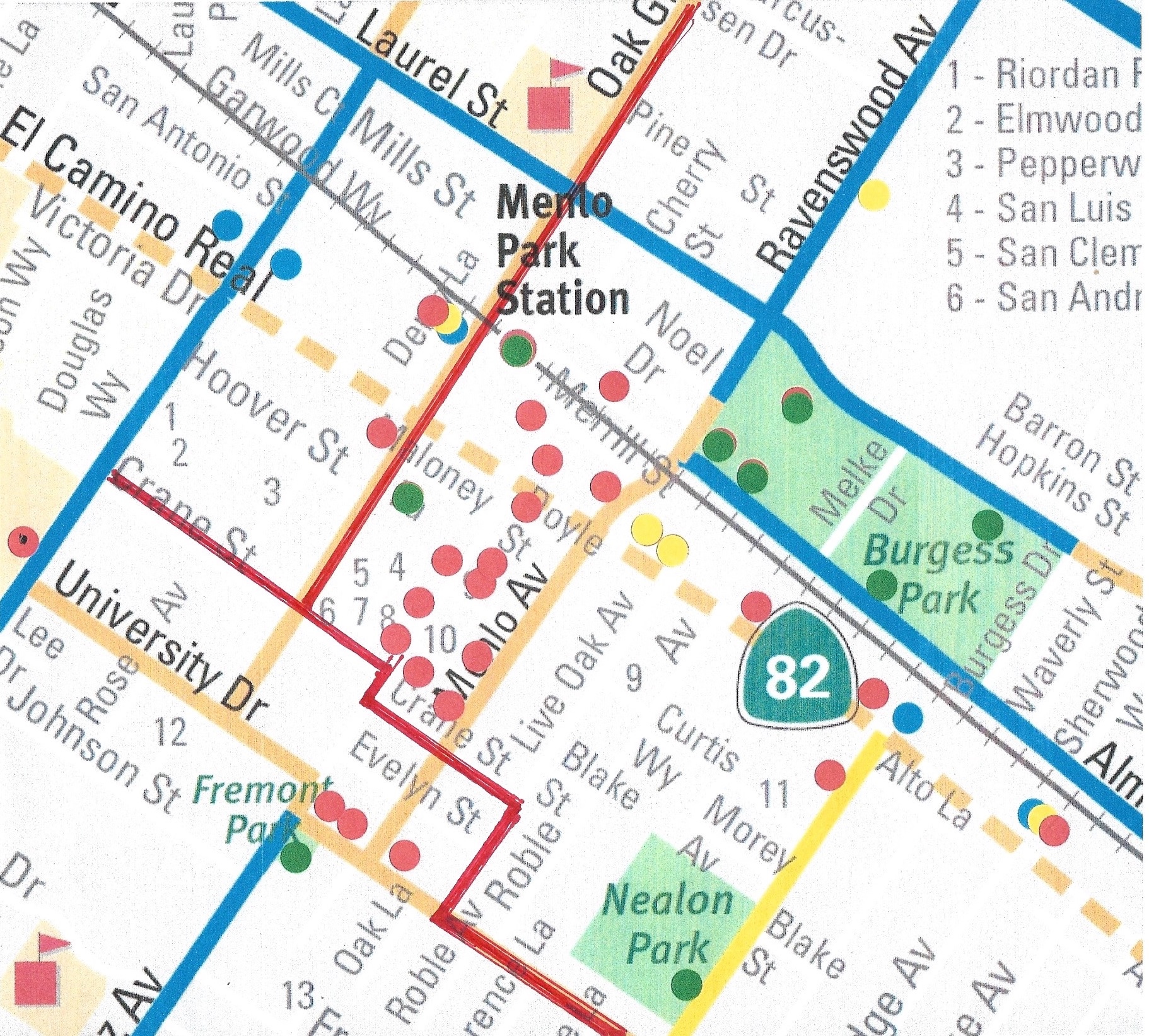
Popular Menlo Park Destinations
Adult bicyclists and parents with school-age children want convenient, safe and stress-free (comfortable) access to all popular Menlo Park destinations both downtown and on opposite sides of El Camino. The two maps below show where these destinations are and the location of exiting bike facilities and routes. Unfortunately, now most destinations within the central area defined by Valparaiso, Glenwood, Middlefield and University cannot be reached using bike lanes
Bike Facility Legend:
Blue lines = Existing Bike Lanes Orange lines = Popular streets that lack bike lanes Yellow = School Bike Route Signage
Destination Legend:
Red dot w/black center = Schools Red dot= Retail Green dot= Parks & Public Facilities Blue dot = Multi-Unit Residential Yellow dot= Business Offices
Central Community Map
Note how many civic and commercial destinations are located south of Ravenswood between Laurel and El Camino. In particular, Cornerstone, Schwab, BevMo, Staples and Big 5 are on a commercial island that cannot easily be reached when riding west on Ravenswood.

Note: Fremont Avenue should be shown in orange as it is a popular with bicyclists who want to travel north-south and bypass both University and downtown.
Downtown & El Camino Specific Plan View
Note how many destinations are located either on or near Menlo Avenue including Trader Joe’s, Walgreens, the Farmer’s Market, Starbuck’s, Wells Fargo, Bank of America, Peet’s, Menlo 800 and Draeger’s and on/near Ravenswood including the library, gym, playing fields, swimming pools, and civic center.
The Specific Plan proposes new bike lanes on Menlo, University, Oak Grove and Middle. Today Menlo and University have shared lanes and street markings. Oak Grove has no bike facilities. Middle between Love and University is a Bike Safety Share Route with a separate lane for bike riding and parking but does not have bike route signage.

Red dot w/black center = Schools Red dot= Retail Green dot= Parks & Public Facilities Blue dot = Multi-Unit Residential Yellow dot= Business Offices
[/vc_column_text][vc_separator][/vc_column][/vc_row][vc_row][vc_column][vc_column_text]
Advantages/Drawbacks of Oak Grove Bike Corridor
Convenient Access to Popular Menlo Park Destinations
- The Oak Grove proposal appears to provide roughly the same convenience as the nearby Valparaiso-Glenwood bike corridor that was recently upgraded This work was specifically designed to serve students who must access schools on the other side of El Camino, e.g. Hillview Middle School, M-A High School, Menlo School, Sacred Heart, St Raymond’s, and Encinal. Both appeal mostly to bicyclists with trips that both originate and end north of Santa Cruz and Ravenswood. Neither generally appeals to bicyclists traveling to downtown and popular destinations on either side of El Camino IF they prefer to use Middle, University and Santa Cruz on the west side and Ravenswood, Alma and Willow on the east side. The required detours are simply too long. (Negative)
Red line = Proposed bike lanes & routes
The study claims the new bike facilities would serve bicyclists riding to many destinations. However, it seems a big stretch to include Draeger’s, Menlo Farmer’s Market, Trader Joe’s Fremont Park, Nealon Park and Walgreen’s as none are near Oak Grove, Crane, or the short section of University that would have bike lanes and most can just as easily be accessed using the bike lanes on Valparaiso, Glenwood and Laurel. (Highly Questionable Claim).

- Adding buffered bike lanes along University would greatly improve the comfort of both bicyclists and motorists who share this busy street to access downtown Menlo Park. More residents would likely use bikes to travel downtown. Also, many bicyclists already cross El Camino Real at Ravenswood so improving University would benefit those who approach Menlo Avenue from Middle. (Positive)
- The proposed bike route between University at Live Oak and Oak Grove at Crane is not intuitive and likely will confuse those unfamiliar with downtown Menlo Park. There are five turns and bicyclists must cross traffic at four intersections on the west side, at El Camino, and three intersections on the east side. (Negative)
Safe & Comfortable Bike Access
- On the west side of El Camino the primary approach to Oak Grove consists of University, Live Oak and three sections of Crane. Unfortunately, motorists and bicyclists would continue to share vehicle lanes on the narrow and busy sections of Crane between Menlo and University and between University and Oak Grove. This is uncomfortable for both motorists and bicyclists as there is no room for much water vehicles to pass bikes. (Negative)
- No bike lanes connect existing Santa Cruz bike lanes to the Oak Grove Corridor so bicyclists must bridge this big gap by sharing our busy and narrow downtown main street all the way to Crane. Distracted motorists and bicyclists will create dangerous situations and there is too little space to avoid accidents and collisions. The speed limit on Santa Cruz is currently 25 mph and few bicyclists ride more than 12 mph – 50% less than vehicles. (Note: the Bike Commission included this section of Santa Cruz in its prior proposal but withdrew it likely because street “share” markings would not have improved either safety or comfort.) (Negative)
- The level of safety in a bike riding environment is largely a function of the number and kind of places where bikes and vehicles cross paths, i.e., conflict points, and the signs and controls used to manage their interactions. These locations include intersections and entrance/exits to public parking like plazas. The Oak Grove corridor has a large number of “conflict points” on Oak Grove and the nearest section of Crane. (Negative)
Impact On Other Street Users
- Between 130 and 177 street parking spaces along Oak Grove Avenue and University Drive will be eliminated. The City does not have a good understanding of the impact on businesses, property owners and residents as it did not perform a formal survey of all Menlo Park residents, especially those on Oak Grove. (Negative)
- Motorist will encounter bicyclist at a greater number of conflict points. (Negative)
- Fire Station 6 located at the corner of Oak Grove and Hoover Street is the busiest in Fire District so emergency vehicles will encounter more bicyclists on Oak Grove. (Impact???)
Additional Concerns
- Downtown Santa Cruz is a poor place to ride bikes due to its narrow vehicle lanes, street parking, multiple street dining areas and many distractions. Unfortunately, the Crane-Santa Cruz intersections will spur bicyclists to ride on Santa Cruz. Bicyclists should be encouraged to access these destinations from side streets and park at the nearest bike posts.
- The complex street configuration on busy Oak Grove near the new Garwood Way, Merrill, the train tracks and Alma appears to create an unsafe and stressful bike riding environment.
- The complex street configuration created by the two intersections needed to cross Santa Cruz on Crane appears hazardous. The presence of a new stop sign and bike riders would like create vehicle congestion.
Select image to see a larger view.
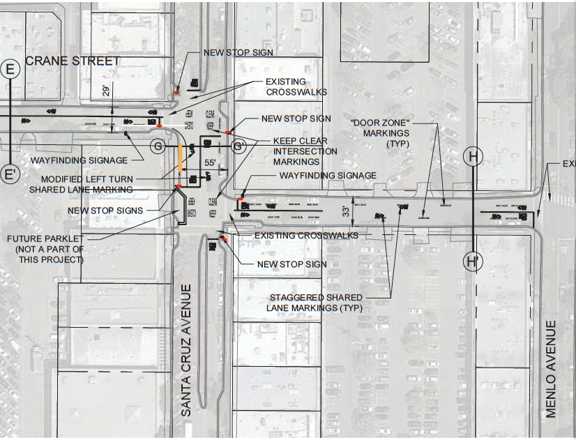
- Crane between Menlo and Oak Grove is a poor location for a bike route. It’s narrow, there are four parking plaza entries and exits, and vehicle traffic is significant. What will happen if a business like The Refuge wants to add street dining areas?
- The loss of 10 minute street parking spaces near the post office could generate a strong backlash from residents as this is a very popular destination and users are frequently carrying packages. Parking in the rear parking plaza is already difficult due to high utilization and side streets offer little relief.
- The loss of Oak Grove street parking near station 1300 could negatively impact on-site stores and restaurants.
- How will the construction at station 1300 (late spring 2017 to late spring 2019) impact a field trial.
[/vc_column_text][vc_separator][vc_column_text]
Additional Resources
Oak Grove Field Trial Authorization Report (December 2016)
Oak Grove Bike Corridor – Bike Commission Presentation (July 2016)
Menlo-Ravenswood Bike Corridor (Updated October 2016)
Which Was-West Bike Proposal Is The Best – Oak Grove or Menlo-Ravenswood? (Updated October 2016)[/vc_column_text][vc_column_text]
Project Calendar
On February 9, 2016, the City Council approved the 2016 Work Plan.
On May 3, 2016, City Council provided direction to amend the Work Plan to prioritize evaluation of bicycle improvements on Oak Grove Avenue, Crane Street and University Drive. ”
On July 19, 2016 staff reported on its progress. Alta Planning & Design, the bike network design firm that helped the City create its 2005 Bike Development Plan, is also assisting in the current work. The initial staff report is available at the City website.

On December 6, 2016 the City Council approved a field trial to start in 2017. Staff Report
At March 28, 2107 City Council meeting trail metrics were proposed and discussed. Staff Report
- Serious concerns expressed about the need to increase public outreach before and during the a field trial. Council members added new requirements.
- Council approved parking, speed and volume metrics and instructed staff to collect benchmark data as soon as possible
- Staff said it felt the earliest start of the trial would likely move from July to September-October timeframe and will return by June with assessment of the impact of changing the proposed trial metrics.
[/vc_column_text][vc_separator color=”black”][/vc_column][/vc_row][vc_row][vc_column][vc_column_text][/vc_column_text][/vc_column][/vc_row][vc_row][vc_column][vc_message color=”alert-info”]
Menlo Park: Grant pays for safer routes to school
by Kate Bradshaw / Almanac – February 2, 2016
The city of Menlo Park has received a $498,783 grant from OneBayArea, a transportation fund of the Metropolitan Transportation Commission, to pay most of the cost of a project to increase bike and pedestrian safety for Menlo Park and Atherton students.
The project will create a continuous pedestrian pathway along Valparaiso Avenue that will be clear of vegetation or other obstacles, enhance bike lanes with a “green” road treatment to increase vehicle awareness, and improve pedestrian and bicycle crossings along Valparaiso Avenue.
Total cost of the project is expected to be about $564,000; the city will pay the remaining $65,000 or so.[/vc_message][/vc_column][/vc_row][vc_row][vc_column][/vc_column][/vc_row][vc_row][vc_column][/vc_column][/vc_row]