[vc_row][vc_column width=”1/1″][vc_column_text]
My Recommendation
The greatest need is providing a safe, comfortable and convenient bike connection for riders to access and cross El Camino at a central location.
This capability can ONLY be achieved by transforming Menlo and Ravenswood Avenues to a world class bike corridor, and this has been shown to be feasible. It could be implemented in less than 12 months IF the City Council made it a high priority. Sadly, improving the city bike network remains a low-urgency priority so the existing riders on this popular route will be unnecessarily exposed to high levels of stress and danger and others who chose not to ride here must continue to wrestle with unnecessary inconvenience.
Come election time residents should support candidates who understand the need for a better community bike network, appreciates potential solutions and will advocate for necessary actions. Today there is none. Everyone complains about vehicle congestion but little is done to deal with it. Improving local bike facilities is a key element.[/vc_column_text][vc_message color=”alert-info” style=”rounded”]
Menlo Park: Grant pays for safer routes to school
by Kate Bradshaw / Almanac – February 2, 2016
The city of Menlo Park has received a $498,783 grant from OneBayArea, a transportation fund of the Metropolitan Transportation Commission, to pay most of the cost of a project to increase bike and pedestrian safety for Menlo Park and Atherton students.
The project will create a continuous pedestrian pathway along Valparaiso Avenue that will be clear of vegetation or other obstacles, enhance bike lanes with a “green” road treatment to increase vehicle awareness, and improve pedestrian and bicycle crossings along Valparaiso Avenue.
Total cost of the project is expected to be about $564,000; the city will pay the remaining $65,000 or so.[/vc_message][vc_column_text]
Natural East-West Bike Corridor Locations
There are three natural locations for building east-west bike corridors in Menlo Park, and together these would provide safe, comfortable, and convenient access to downtown and both sides of the city from the Alameda de Las Pulgas and Middlefield Road and all points in between.
- North-end: Valparaiso, Glenwood, Laurel, Encinal and Ravenswood.
- Central: Menlo and Ravenswood and either Santa Cruz or Middle and University.
- South-end: Oak Avenue, Middle, Alma and either Ravenswood or Willow
All the streets at the north-end of have bike lanes except Glenwood between El Camino Real and Alma.
Menlo and University have no bike facilities and only “share-the-street” pavement markings (‘sharrows”). Ravenswood has an awkward mix of bike lanes and sharrows and a difficult crossing at El Camino. Santa Cruz has no bike facilities downtown between University and El Camino Real.
Middle has no bike facilities just a few school safety route signs. Oak has sharrows.
Note: sharrows provide cyclists no protection when they share vehicle lanes on narrow streets with street side parking.

Blue lines = Natural bike corridors and approaches
Green lines = popular routes outside the existing bike network[/vc_column_text][vc_column_text]
Current Efforts
[/vc_column_text][vc_column_text]
Two different design concepts for east-west bike corridors have been submitted to Menlo Park, one based on Oak Grove Avenue which is at the north end of El Camino and another on Menlo-Ravenswood Avenues near the mid-point of the city’s only main vehicle artery.
[/vc_column_text][/vc_column][/vc_row][vc_row][vc_column width=”1/1″][vc_column_text]
Oak Grove Bike Corridor

This bike corridor would appeal primarily to bicyclists with trip origins and destinations located north of Ravenswood and Santa Cruz Avenue; it not be convenient for other bicyclists because the corridor introduces detours.
Proposed Design
Buffered bike lanes on Oak Grove Avenue between Crane Street and Middlefield Road
Buffered bike lanes on University Avenue between Middle Street and Live Oak
Bike routes on Crane between Live Oak and Oak Grove
Bike routes on Live Oak between University Avenue and Crane Street
Shared vehicle lanes on Santa Cruz between University Avenue and Crane Street ( two blocks)
* Field Trial Cost estimate: Unknown
* Total Cost: Unknown[/vc_column_text][vc_column_text]
Advantages/Drawbacks of Oak Grove Bike Corridor
(Plus) Most convenient route for bike trips with origins and end points located north of Santa Cruz and Ravenswood Avenues.
(Plus) Increases comfort and safety for bicyclists who use this route.
(Minus) Less convenient route than Menlo-Ravenswood for bike trips with origins and endpoints either on or south of Santa Cruz and Ravenswood Avenues.
(Minus) Eliminates more than 110 street parking spaces.
(Minus) Implementation schedule tied to the construction of station 1300 which is expected to open in 2019.
(Minus) Encourages bicyclists to share vehicle lanes on Santa Cruz between University Avenue and Crane Streets, a solution which will be inconvenient and stressful for motorists and unsafe and stressful for bicyclists. Currently motorists cannot safely pass bicyclists because the vehicle lane is too narrow due to street parking.The speed limit on Santa Cruz is 25 mph and few bicyclists ride as fast as 15 mph.
(Minus) Less safe and comfortable than Menlo-Ravensood due to larger number of “conflict zones” where bikes and vehicles can cross paths. Conflict zones include crossing intersections and busy public driveways.[/vc_column_text][vc_column_text]
Menlo-Ravenswood Bike Corridor

This bike corridor should appeal to bicyclists who would prefer travel on Middle, Santa Cruz , Menlo and Ravenswood Avenues.
Proposed Design
2-way protected bike lanes on the south side of Menlo Avenue between Crane and El Camino Real.
2-way protected bike lanes on the south side of Ravenswood between El Camino Real.
Separate 2-way bike path parallel to Ravenswood between Alma and Laurel Streets.
2-way protected bike lanes on the west side of University Avenue between Middle and Live Oak.
Bike route signage and street marking on Live Oak between University Avenue and Crane Street; and these to Crane between Live Oak and Menlo Avenue.
2-way bike lanes in parking lots behind stores on the south side of Santa Cruz between University and Crane.
.
* Field Trial Cost estimate: unknown
* Total Cost: unknown[/vc_column_text][vc_column_text]
Advantages/Drawbacks of Menlo-Ravenswood Bike Corridor
(Plus) Most convenient route for bike trips with BOTH origins and destinations locate either on or south of Santa Cruz and Ravenswood Avenues.
(Plus) Increases the safety and comfort for bike riders on THE MOST POPULAR east-west bike route in Menlo Park. Currently motorists cannot safely pass bicyclists because the vehicle lane is too narrow due to street parking. California state law requires that motorists maintain a passing distance of at least. The speed limit is 30 mph and few bicyclists ride as fast as 15 mph.
(Plus) Likely could be implemented within 12 months => 2017.
(Plus) Adds an attractive bike path across city property between Alma and Laurel.
(Minus) Eliminates about 45 street parking spaces.
(Minus) Bike connection between University and Crane requires either bike lanes thru two parking lots or shared vehicle lanes on Santa Cruz like the Oak Grove bike corridor design. Otherwise bicyclists must continue to share vehicle lanes on short sections of University and Menlo Avenues.[/vc_column_text][vc_column_text]
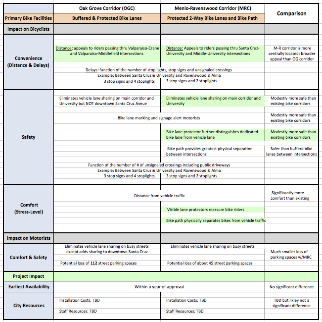
Comparison Summary
This table illustrates the primary difference between the two bike corridors based on the expected impact each would likely have on bicyclist and motorist convenience, safety and comfort. It also compares project schedules, staff resource impact and funding requirements. The summary does not address the needs and concerns of other street users, i.e., pedestrians, retailers, public safety service providers and property owners.

[/vc_column_text][vc_separator color=”grey”][vc_column_text]
Menlo Park Bike Commission Observations
View an on-going discussion with the Menlo Park Bike Commission.[/vc_column_text][vc_separator color=”black”][vc_column_text]
Go To
Oak Grove Bike Corridor Proposal
Menlo-Ravenswood Bike Corridor Proposal
[/vc_column_text][/vc_column][/vc_row][vc_row][vc_column width=”1/1″][vc_column_text]
[/vc_column_text][/vc_column][/vc_row][vc_row][vc_column width=”1/1″][vc_column_text]
[/vc_column_text][/vc_column][/vc_row][vc_row][vc_column width=”1/1″][vc_column_text]
[/vc_column_text][/vc_column][/vc_row][vc_row][vc_column width=”1/1″][vc_column_text]
[/vc_column_text][/vc_column][/vc_row][vc_row][vc_column width=”1/1″][vc_column_text]
[/vc_column_text][/vc_column][/vc_row][vc_row][vc_column width=”1/1″][vc_column_text]
[/vc_column_text][/vc_column][/vc_row][vc_row][vc_column width=”1/1″][vc_column_text]
[/vc_column_text][/vc_column][/vc_row][vc_row][vc_column width=”1/1″][vc_column_text]
[/vc_column_text][/vc_column][/vc_row][vc_row][vc_column width=”1/1″][vc_column_text]
[/vc_column_text][/vc_column][/vc_row][vc_row][vc_column width=”1/1″][vc_column_text]
[/vc_column_text][/vc_column][/vc_row][vc_row][vc_column width=”1/1″][vc_column_text]
[/vc_column_text][/vc_column][/vc_row][vc_row][vc_column width=”1/1″][vc_column_text]
[/vc_column_text][/vc_column][/vc_row]